


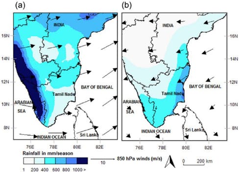
Northeast Monsoon (NEM) is the often-neglected smaller cousin of the Southwest Monsoon (SWM) – i.e., the famous Indian summer monsoon. However, this is nothing to be sneezed at for, it provides ~15% of the country’s annual rainfall and over 80% of annual rainfall in southeastern peninsula. In particular, central, and eastern parts of Tamil Nadu and Andhra Pradesh. This can be seen in the spatial average rainfall over southern India in the Figure at the bottom – (a) summer (June-September) average rainfall, (b) winter (October – December) average rainfall.
The summer monsoon with its national impact, understandably, has a long history of scientific research since late 19th century. British meteorologists, Sir Gilbert Walker and Henry Blanford pioneered monsoon research during British Indian rule in India. We briefly touched on Blanford’s contribution in the second part of this series, will have more in subsequent parts. There is no such counterpart for the NEM.
Basics: In the first part of this series, we saw the wind pattern during summer (Jun-Sep) and winter (Oct-Dec) – see the figure at the bottom. The hall mark of Indian subcontinent is that the winds are diametrically opposite during summer and winter. During summer, the winds blow from Arabian Sea to the Indian land moving from southwest to northeast. Also, winds from central and Northern Bay of Bengal blow on to Indian region from southeast to northwest. With it, they bring moisture producing rains over the subcontinent during summer.
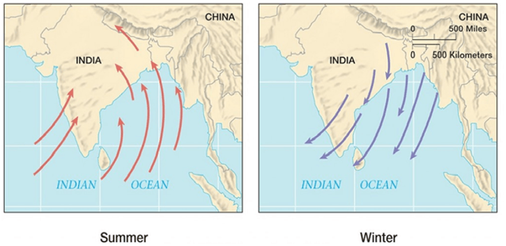
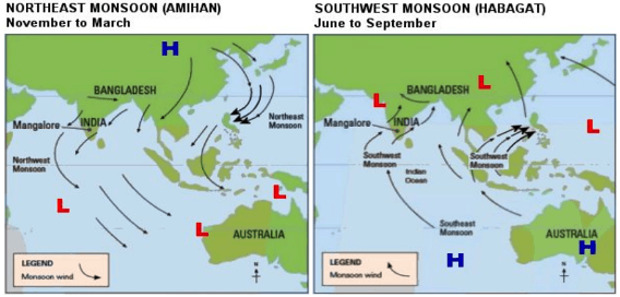
Notice that southeast peninsula (Tamil Nadu and southern Andhra Pradesh) is missed by these large-scale wind patterns. Western ghats topography (see part 3 of the series) plays a role in reduced rainfall over southeastern peninsula and consequently enabling winds from Bay of Bengal. We also saw from the first part of this series that the summer monsoon covers the entire country by July – August. During September and into October the northern hemisphere starts to get cooler which weakens the temperature gradient between land (Indian subcontinent and surrounding) and the Indian Ocean, resulting in the withdrawal of the summer monsoon. In other words, the winds start to reverse (see Figure above). In addition, the Eurasian land also starts to cool resulting in higher pressure – cooler/cold air is heavier than warm air thus it sinks to the surface leading to high pressure. While the lower pressure is over the equatorial region, vice-versa during summer. This pressure differential leads to air moving from higher pressure region to lower pressure – i.e., northeast to southwest. The pressures and the consequent wind patterns during summer and winter are shown in the Figure below. The pressure differential is also responsible for the withdrawal of the summer monsoon. As this withdrawal occurs it brings winds over northern Bay of Bengal on to southeast India, which is the main feature of NEM.
The NEM has a smaller window compared to the summer monsoon. This is because the higher pressure over Eurasia progressively and rapidly strengthens with the marching into winter season from October. Consequently, the winds blowing over to southeastern Peninsula become colder, which is not conducive for carrying moisture and hence, rainfall.
NEM-SWM Connection: Interestingly, the NEM and the SWM are anti-correlated via El Nino Southern Oscillation (ENSO), a phenomenon in the tropical Pacific Ocean. During El Nino years, SWM tends to be weaker and NEM stronger.
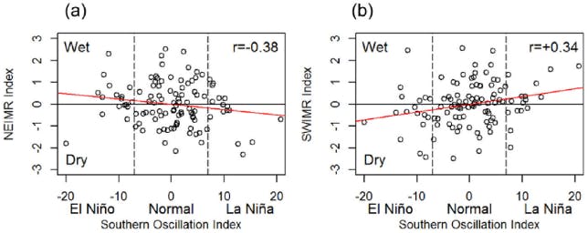
Vice-versa during La Nina years. As can be seen in the Figure below – (a) for NEM and (b) for SWM. This current winter season (Oct-Dec 2022) is under the influence of La Nina, thus, reduced NEM rainfall thus far. We will explore the role of ENSO in driving the space-time variability of rainfall over India in subsequent parts of this series. The anti-correlation of NEM and SWM also helped in the rise and economic prosperity of the Chola Kingdom from 850 to 1280 CE – a period approximately coinciding with the Medieval Climatic Anomaly. See the figure on the bottom (from this interesting paper). The period between ~850 and ~1300 CE, a time of frequent El Niño-like conditions, was associated with a substantial increase in NEM, whereas SWM suffered substantial deficits. The spatial pattern and chronology of water harvesting infrastructure development under Chola rule indicate that these features were concentrated in the NEM-receiving regions of southeastern India and that their construction peaked during El Niño-dominated intervals.
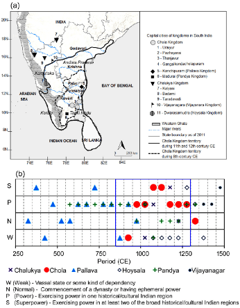
Overall, enhanced NEM conditions and adaptation strategies practiced in the Chola’s territory, combined with less favorable climatic conditions over the neighboring kingdoms, appears to have underpinned the well-documented political and economic strengths of the Chola superpower. We infer that the water management infrastructure promoted by the Chola rulers helped to buffer the consequences of climatic extremes in later history. More recently, however, a preference for groundwater irrigation and other landscape changes driven by population pressure has made the region more vulnerable to the incidence of heavy NEIMR episodes, as illustrated by the severe floods of 2015. Future climate adaptation planning in South India should appreciate the merits of restoring and expanding the currently decaying legacy of Chola-style water management infrastructures.