In the last edition we saw the broad atmospheric circulation over the Indian subcontinent and surrounding Indian Ocean region. This circulation and consequently, the rainfall is driven in large part due to the temperature gradient between the landmass and the Northern Indian Ocean that gets set up during March – May (i.e. Indian summer). Here we will see the role of topography.
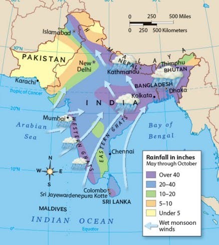
Topographical Effect: The average summer monsoon rainfall over India can be seen in the figure below. The spatial variability is amply clear. As we can see high rainfall regions are along the west coast, along with the foothills of Himalayas and East India. This spatial non-uniformity in rainfall is largely due to topography. Moisture laden winds when obstructed by topography (mountains, hills etc.) are pushed up the slope of these features thereby dropping all the moisture along the slopes and foothills. This is a topographical effect in a nutshell.
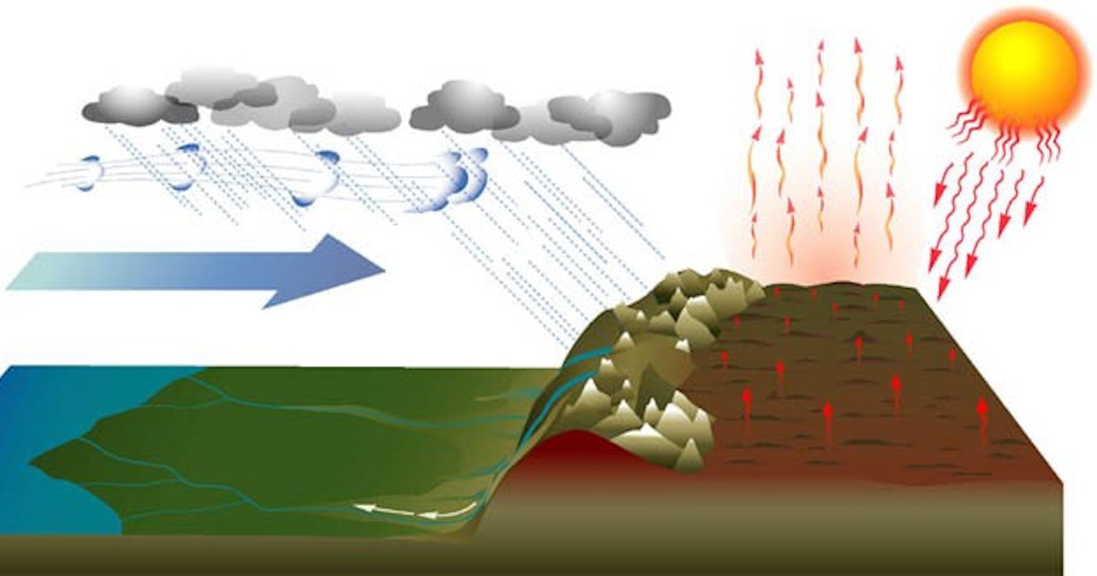
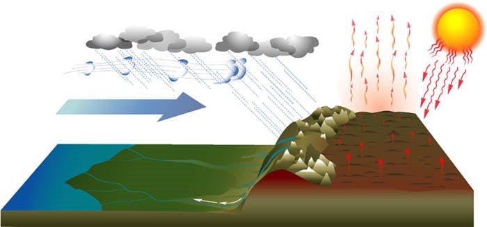
Himalayas – Tibet: The Himalayas play a crucial role in the onset and sustenance of the summer monsoon. The physical mechanism is very simple (see Figure to the side). The mountains with their tall peaks absorb solar heat and then heat the atmosphere at a very high elevation above the peaks. This heating produces a ‘thermal low’, which pulls moisture laden winds from the ocean onto the land. Thereby, delivering moisture over the land and more at the foothills. For this ‘thermal low’ to be of consequence, it must be strong and broad over a large area.
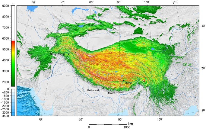
If the mountains are narrow peaks they are not conducive for this. It is here that the Himalayas are unique and play a vital role. The front range of the Himalayan Mountain (i.e. the windward side) covers the entire stretch of Indian subcontinent from Kashmir in the North to Arunachal Pradesh in the East. To the leeward side just beyond the peaks visible to us from the foothills is the Tibetan plateau. This plateau is vast (~, situated around 5 Kilometers high from sea level and arid (see figure below, showing the plateau and the elevation for perspective). These aspects make the plateau unique among all mountains on the planet. In the winter it is covered in snow and during spring (March – May) with solar radiation the snow melts and the atmosphere above the plateau also gets heated. This heating creates the aforementioned ‘thermal low’ during spring that ‘pulls’ moisture from the Indian Ocean, heralding the onset of the monsoon.
Depending on the amount of snow over Tibet in the winter, the heating of the atmosphere over the plateau is modulated. For example, if the winter snow was above normal, then much of the solar radiation in spring goes towards melting the snow and less towards heating the overlying atmosphere and vice-versa during years with below normal snow. This variation in the winter snow contributes to the variation in the strength of ‘thermal low’ over the plateau and thus contributes to the variability of monsoon rainfall. This is also known as the ‘Elevated Heat Pump’ (EHP) hypothesis – shown in the simplified schematic figure below (the plateau is shown as the elevated surface). The winter snowfall over the Tibetan plateau is produced by physical mechanisms of the mid-latitudes such as the sub-tropical jet, Arctic Oscillation etc. Thus, the Tibetan plateau plays a crucial role in connecting the winter climate with the summer monsoon. Its location, mainly in the sub-tropics, vast and arid, makes it an important aspect of Indian monsoon. The projection of the Himalayas above the Tibetan plateau 15 Million Years ago has led to development of the Indian summer monsoon in its present form. Prior to this the rainfall over India was ‘monsoon like’ but due to the annual change of seasons from Earth’s revolution around the Sun and the movement of Inter Tropical Convergence Zone (ITCZ) to the northern hemisphere (we will discuss this in the following editions). As a result, the Indian monsoon is one of the stable climate systems on the entire planet. If you ever wondered why the rains come like clockwork every year, you must thank the Himalayas, especially the Tibetan plateau.
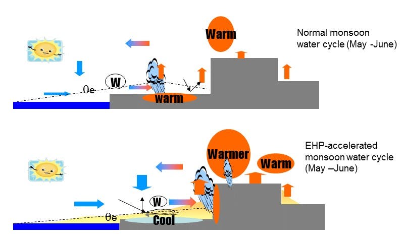
Interestingly, the British meteorologist Henry Blanford was the first to notice a connection between winter snowfall (snow cover) over Eurasia including the Tibetan plateau and the subsequent summer monsoon, way back in 1884!. The physical mechanics is same as described before – in that, higher snowfall and snow cover leads to weaker ‘thermal low’, as most of the solar radiation goes towards melting the snow and thus, weaker monsoon circulation. This is shown in the schematic below figure where the winds blow from land to ocean (which is not conducive for rainfall) and vice-versa during years of less snowfall (bottom panel). Thus, a drier winter over Eurasia favors a stronger summer monsoon. This highlights the interconnectedness of various climate systems on the planet.
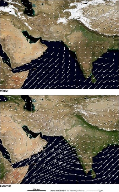
While the role of Tibet and Eurasian snow has been known for a long time, there is renewed interest in understanding the role of Tibetan plateau in modulating the Indian monsoon rainfall beyond the onset. In addition, how does changes in snowfall over Eurasia due to global warming impact the heating of the Tibetan plateau and consequently, the monsoon. These are fascinating questions.
Next edition: Tibetan plateau heating is one of the drivers of monsoon. We will investigate the role of Western Ghats and the land surface of the Indian subcontinent.

