


In the last edition we saw the important role of spring season snow and temperatures over the Himalayas, especially, Tibetan plateau and generally over the larger Eurasian region. In that, higher snow during the winter (i.e. Dec – Feb) and spring (i.e. Mar – May) seasons preceding the monsoon season (Jun – Sep) leads to cooler atmospheric temperatures over this entire region relative to the Indian Ocean and consequently, a weaker monsoon circulation and potential below normal monsoon and, vice-versa.
In this edition, we will see the role of topography of the Indian subcontinent.
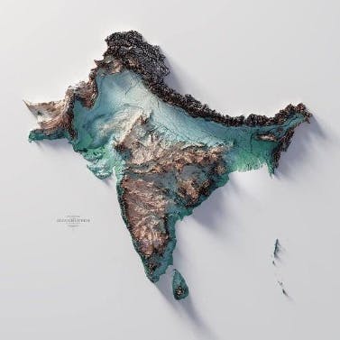
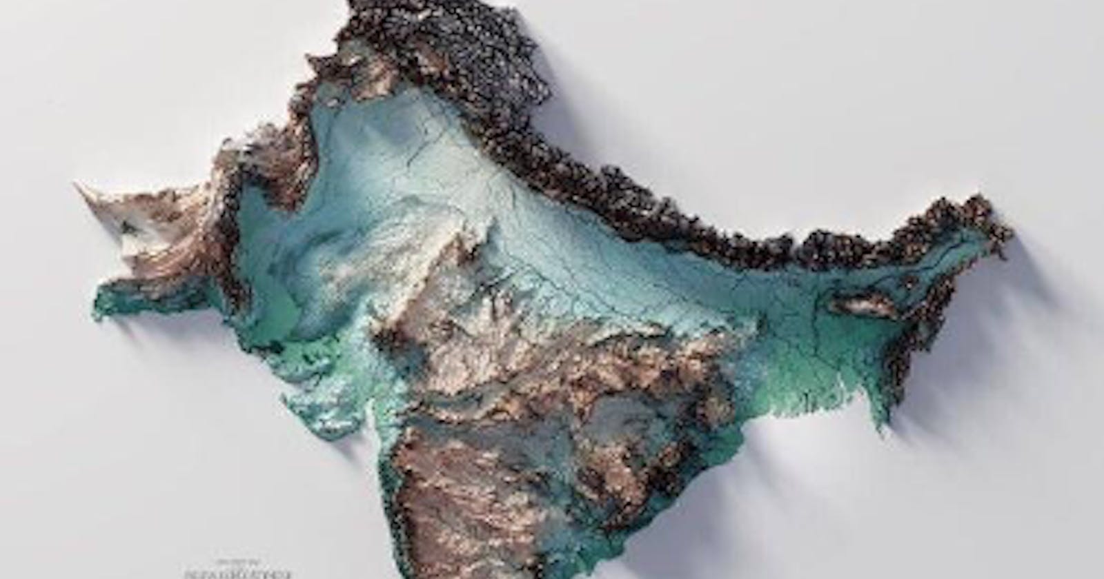
Topography of Indian Subcontinent: The topography of Indian subcontinent is unique (see the relief map above) in the world and thus, it plays a crucial role in the spatial variability of rainfall and also the large-scale monsoon circulation during the season. The striking feature is the Himalayan mountain range, which stretches from Kashmir, in the north to all the way to the Northeastern tip of India. This is a continuous stretch, almost like a long high wall. This creates excellent conditions for water to runoff from the high mountains down to the plains creating long rivers such as Ganges (from northern foothills to the Bay of Bengal) and Brahmaputra (from the northeastern foothills to Bay of Bengal), clearly seen in the figure. Another striking feature in the peninsular India are the Western Ghats which stretch the entire west coast of India from Goa (just to the south of Mumba) to almost the southern tip of India (Kanyakumari) – like a long wall, though not as high as the Himalayas but continuous. However, the eastern Ghats are not continuous, not as tall as the western Ghats and somewhat inland. The central mountains, Vindhyas, span east to west. The backside (i.e. eastern side) of the western ghats is the well known Deccan Plateau and the Ghats slope from west to east covering peninsular India. This general sloping of the Ghats from west to east is the reason for almost all the peninsular rivers – Krishna, Godavari, Cauvery, Pennar, Tamiraparani and Mahanadi to flow east to the Bay of Bengal. Only two rivers – Narmada and Tapti - that originate in the Vindhyas flow west to the Arabian sea. The geomorphology of central and south India and the rivers it creates is a fascinating topic in itself – perhaps for another edition.
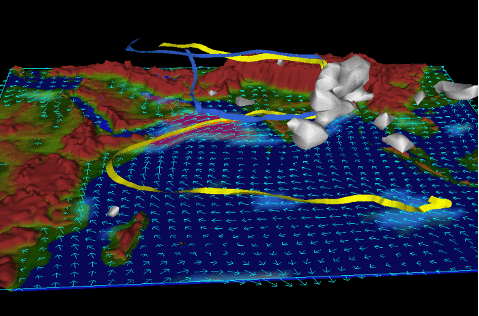
Topographical Effect and Spatial Variability: In a previous edition we saw the monsoon flow – i.e., the moisture laden atmospheric monsoon jet that veers off the African coast and blowing over Arabian Sea from the coast of Oman, makes a beeline to the western and southwestern side of Indian sub-continent. This strong atmospheric flow from southwest of India to northeast is the iconic and unique aspect of Indian monsoon – hence, the term southwest monsoon. This is not found anywhere else in the global climate system and thus, sets the Indian monsoon apart. This flow can be clearly seen in the figure above. The yellow ribbon denotes the moist lighter air, and the blue ribbon is the cold heavier air. It is a simple fact that topography obstructs flow of air, more so topography that is tall and continuous like a wall. As described in the previous section, the first obstruction to the moist air flow from the jet are the western Ghats. When moist air, which is lighter relative to cold dry air, hits this obstruction, or any for that matter, it rises along the western slopes of the western Ghats. As the moist air rises, it starts to become colder and consequently, cannot hold on to the moisture and thus, it is squeezed out in the form of rainfall. Hence, a lot of rain on the western side (i.e., the windward side) of the western Ghats along the long and narrow stretch of the Arabian coast. As the moist air rises and dumps rain, it gets colder and thus, heavier, and descends on the eastern side (i.e., the leeward side) of the western Ghats. As mentioned before, western Ghats are not as tall as the Himalayas, so not all the moisture is squeezed out on the windward side. Thus, some residual moisture is precipitated on the leeward side of the western Ghats that generates water for rivers like Cauvery, Krishna and Godavari. However, the leeward side consisting of the Deccan Plateau as mentioned earlier, receives much less compared to the windward side, thus creating a steep rainfall gradient across the ghats. This is clearly seen in the spatial map of average monsoon season rainfall above. The winds continue their journey northeastward due to the general steering of the monsoon jet. It encounters the Vindhyas and follows the same physics of moist air raining on the windward side – here it is central India that feeds Mahanadi, Narmada and Tapti rivers. As can be seen in the light blue region in central India in the above figure. Finally, the moist air continues its journey before crashing against the mighty Himalayas stretching from North to east of India, where it gives up all of its moisture as it rises along the tall peaks (wall). This water washes down the slopes of the Himalayas and feeds the mighty rivers of Ganges and Brahmaputra and tributaries. Of note is that the prevailing direction of monsoonal flow is from Arabian Sea to Himalayas and this flow misses northwest India. Furthermore, the moist air, after precipitating all the moisture along the face of Himalayas as it rises, gets drier and colder (thus, heavier) and sinks over Northwest India and eastern Pakistan. This sinking dry air is not conducive for rainfall. As a result of these two effects, the region stretching from northern Gujarat through Rajasthan and south of Haryana is dry and also home to the Thar desert.
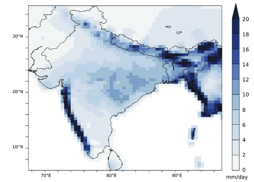
Implications of Spatial Average – i.e., Climatology: The map of spatial average rainfall above, is also known as the monsoon climatology. Meaning, this the annual average rainfall that is typically expected each year due to the interplay between monsoon jet that occurs each year and the unique topography of Indian subcontinent. This climatology is what creates a drier Deccan plateau, Thar desert, and Northwest India, wetter west coast, Himalayan regions, and northeast India. This spatial pattern in rainfall plays a role in shaping the evolution of societies, culture, customs, and food.
We will explore the role of land surface conditions (land use, land cover, temperature etc.) during pre-monsoon over India in driving year-to-year variability of rainfall in the following editions.